Coastal Cruisin'

Coastal Cruisin'

Scenic Ride 09

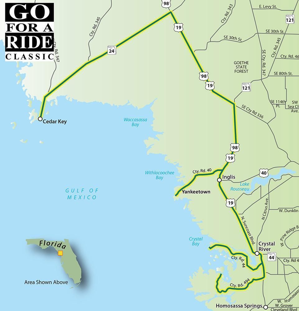
Florida has more than 11,00 miles of coastline. Much of it is covered with condos and hotels but there are still stretches where manatees, bald eagles, and even black bears can be found. Some of the best costal roads are found in an area known as the Nature Coast which stretches from Pasco to Wakulla counties along the Gulf Coast. 

We've selected four coastal byways which run westward from US 19/98. The Ozello Trail is the curviest of the group while you can swim with the manatees at the end of CR 44. Yankeetown was founded in 1923 by a policeman from Indiana and Cedar Key, which was once a small fishing village, is now a tourist getaway desination. 

Road Name - Direction - Miles

  1. Start in Crystal River at intersection of US 19/98 and Ozello Trail
  2. CR 494/W Ozello Trail - West - 9.2 Miles
  3. Ride to bridge at Peck's and return to US 19 - 9.2 Miles
  4. US 19/98 - Left (north) - 1.9 Miles
  5. CR 44 - Left (west) - 9.2 Miles
  6. Ride to boat launch and return to US 19 - 9.2 Miles
  7. US 19/98 - Left (north) - 13.2 Miles
  8. CR 40 - Left (West) - 7.3 Miles
  9. Ride to Yankeetown and return to US 19 - 7.3 Miles
  10. US 19/98 - Left (north) - 22.5 Miles
  11. SR 24 - Left (west) - 21.4 Miles
  12. Now that you're in Cedar Key, relax and enjoy yourself
Download PDF

Continue reading

"O" What A Ride!

"O" What A Ride!

Scenic Ride 08

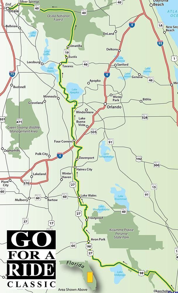
The Interstate highways will get you up and down the peninsular part of Florida quickly on either coast but the good riding is smack dab in the middle of the state. This ride from Okeechobee to Ocala is a backroad honey hole and includes portions of three designated Scenic Byways; The Ridge is at the start, The Green Mountain winds along Lake Apopka, and the Florida Black Bear takes you through the Ocala National Forest. Ride the full route or pick out a slice along the way to enjoy.

Road Name - Direction - Miles

  1. Start in Okeechobee at intersection of SR 70 and US 98
  2. US 98 - North 42.2 Miles
  3. US 98/US 27 - Right 20.6 Miles
  4. SR 17/N Scenic Hwy - Right - 35.0 Miles
  5. E Hinson Ave - Right - 0.3 Miles
  6. US 17/US 92/SR 700 - Left - 4.1 Miles
  7. Magnolia St - Left - 0.1 Miles
  8. Polk 547/Lee Jackson Hwy - Right - 6.3 Miles
  9. Ron Reagan Pkwy/Polk 54 - Left - 3.7 Miles
  10. Champions Gate Blvd - Right - 0.4 Miles
  11. Masters Blvd - Left - 0.8 Miles
  12. S Goodman Rd - Straight - 4.9 Miles
  13. Westside Rd - Right - 2.0 Miles
  14. CR 545/Avalon Rd - Right - 16.3 Miles
  15. Tildenville School Rd - Straight - 0.3 Miles
  16. SR 438/Oakland Ave - Left - 3.1 Miles
  17. SR 438 - Right - 0.4 Miles
  18. Old County Rd 50 - Straight - 1.9 Miles
  19. CR 455 = Straight - .3 Miles
  20. CR 455 - Left - 5.5 Miles
  21. Traffic Circle straight on CR 455 - 1.7 Miles
  22. CR 561 - Right - 8.7 Miles
  23. SR 19 - Right - 2.0 Miles
  24. SR 19/44/500 Burleigh - Right - 3.0 Miles
  25. Ramp for SR 19 - Right - 0.2 Miles
  26. SR 19/Bay St - Left - 1.7 Miles
  27. SGrove St - Straight - 1.1 Miles
  28. SR 19 N - Straight - 22.4 Miles
  29. SR 40 - Left - 32.0 Miles
  30. Ending point is Ocala

Download PDF

Continue reading

Strawberries And Spring Water

Strawberries and Spring Water

Scenic Ride 06

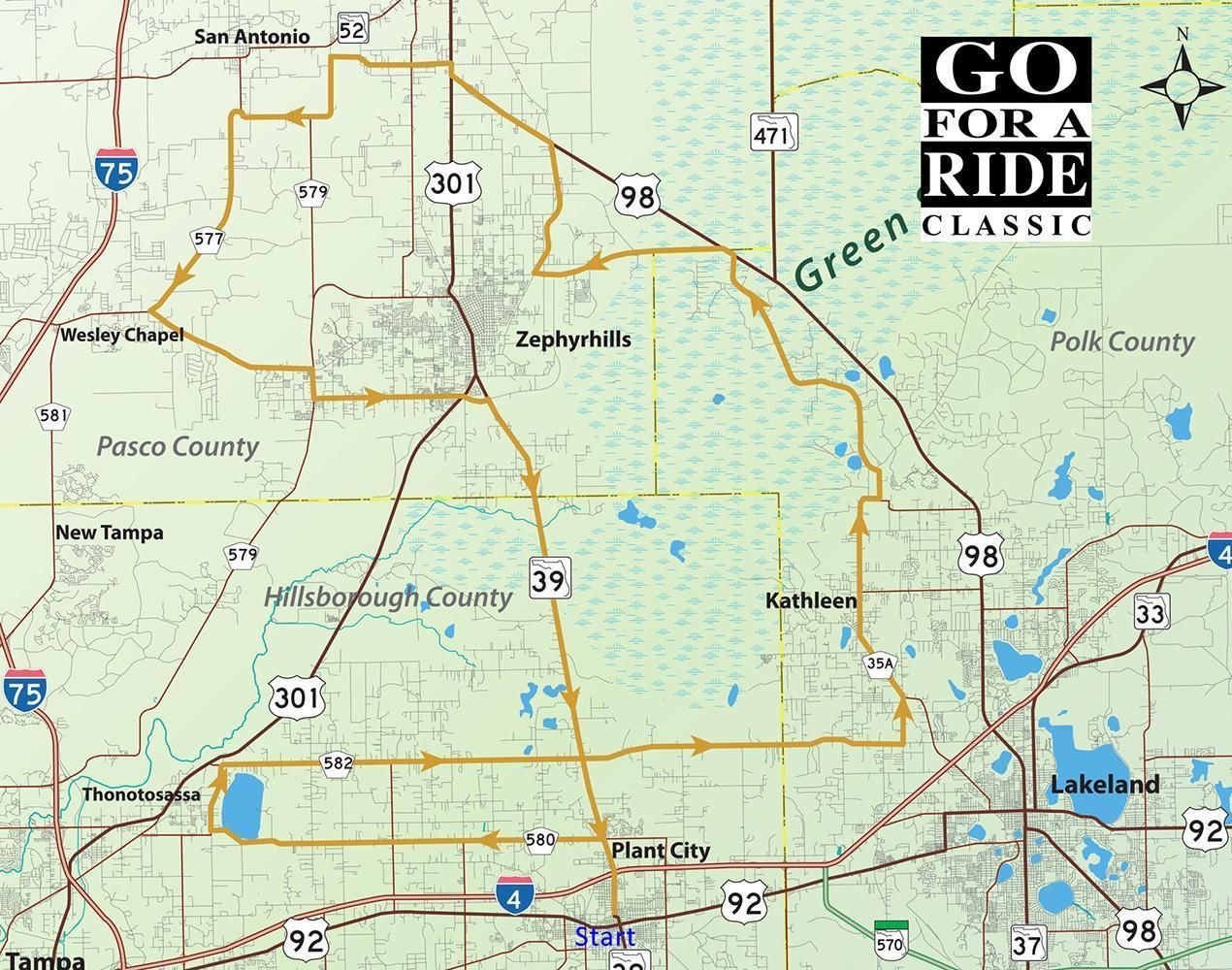
Want strawberries? Go to Plant City. Want spring water? Then it's Zephyrhills. Want a great ride? Follow this route from P-City to Z-hills and back again.

Road Name - Direction - Miles

  1. Start in Plant City - Intersection of Baker St E & N Wheeler St
  2. N Wheeler St - North - 2.2 Miles
  3. Sam Allen Road W - Left - 9.9 Miles
  4. Becomes Thonotosassa Rd
  5. Taylor Rd - Right - 0.5 Miles
  6. Knights Griffin Rd - Right - 18.4 Miles
  7. N Galloway Rd - Left - 1.3 Miles
  8. Kathleen Rd - Left - 5.3 Miles
  9. Socrum Loop Rd - Bear Right - 0.3 Miles
  10. Old Dade City Rd - Left - 8.2 Miles
  11. US 98 - Left - 0.2 Miles
  12. CR 54 - Left - 4.4 Miles
  13. Old Lakeland Hwy - Right - 3.4 Miles
  14. US 98 - Left - 2.8 Miles
  15. US 98/US 301- Bear Right - 0.3 Miles
  16. Clinton Ave - Left - 3.1 Miles
  17. Prospect Rd - Left - 3.8 Miles
  18. Curley Rd - Left - 5.9 Miles
  19. SR 54 - Left - 4.4 Miles
  20. Morris Bridge Rd - Right - 0.7 Miles
  21. Chancey Rd - Left - 4.4 Miles
  22. SR 39/Buchman Hwy - Right - 13.6 Miles
  23. Return to Start

Download PDF

Continue reading

Bridges Of Tampa

Bridges of Tampa Bay

Scenic Ride 07

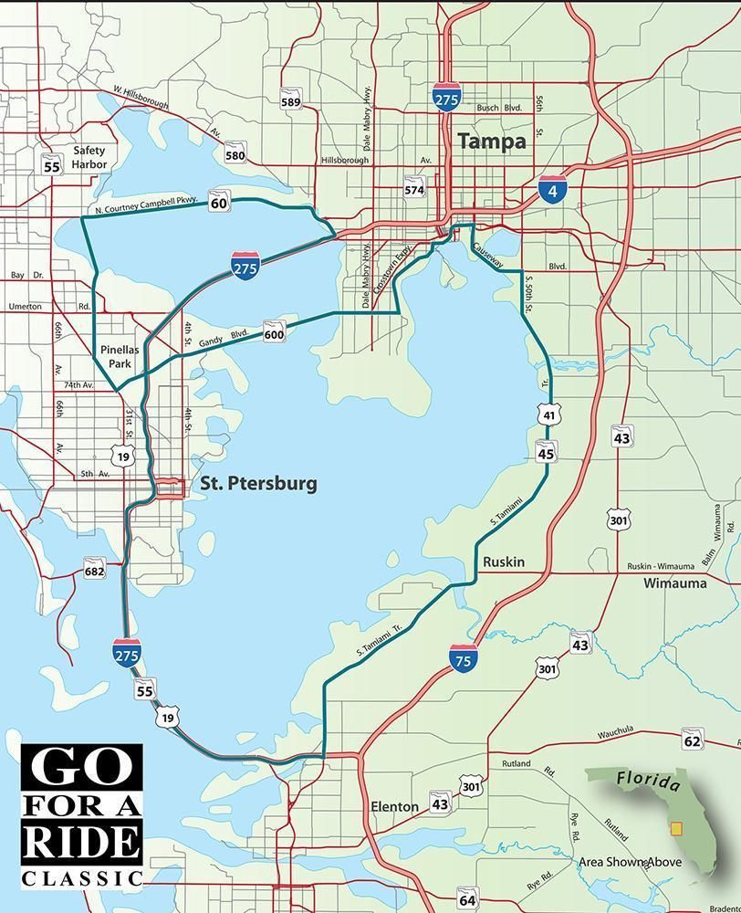
We'll cross that bridge when we come to it and this ride has you crossing all five of Tampa Bay's bridges. This route features some of the best the area has to offer; the palm-lined beaches along the Courtney Campbell Causeway, the unrivaled view from atop the Sunshine Skyway Bridge, the magnificent mansions along Bayshore Boulevard, and the old Florida scenery along US 41. We started our ride in Clearwater, but feel free to pick your own starting point.

Road Name- Direction - Miles

  1. Start at the Intersection of SR 60 and McMullen Booth Rd
  2. SR 60/Gulf to Bay - East - 4.0 Miles
  3. SR 50/Courtney Campbell - Straight - 7.8 Miles
  4. Follow signs to I-275 St Petersburg
  5. 1-275 - South - 36.6 Miles
  6. Sunshine Skyway toll is $1.50 or uses your SunPass
  7. Exit 2/US 41 North - North - 28.6 Miles
  8. Causeway Blvd - Left - 3.7 Miles
  9. SR 60/Adamo Dr - Left - 0.7 Miles
  10. Channelside Drive - Left - 0.7 Miles
  11. Construction on the Water Street Project may
  12. require
  13. some detours to get to Bayshore Blvd.
  14. Traffic circle/Channelside - Right - 0.3 Miles
  15. Union Station St - Right - 0.2 Miles
  16. E Borein/e Cumberland - Straight - 0.5 Miles
  17. Bayshore Blvd - Left - 4.4 Miles
  18. W Gandy Blvd - Right - 12.6 Miles
  19. US 19 North - Right - 1.6 Miles
  20. CR 611/49th Street - Right - 6.6 Miles
  21. Return to the Start.

Download PDF

Continue reading

Meandering In Manatee

Meandering in Manatee

Scenic Ride 05

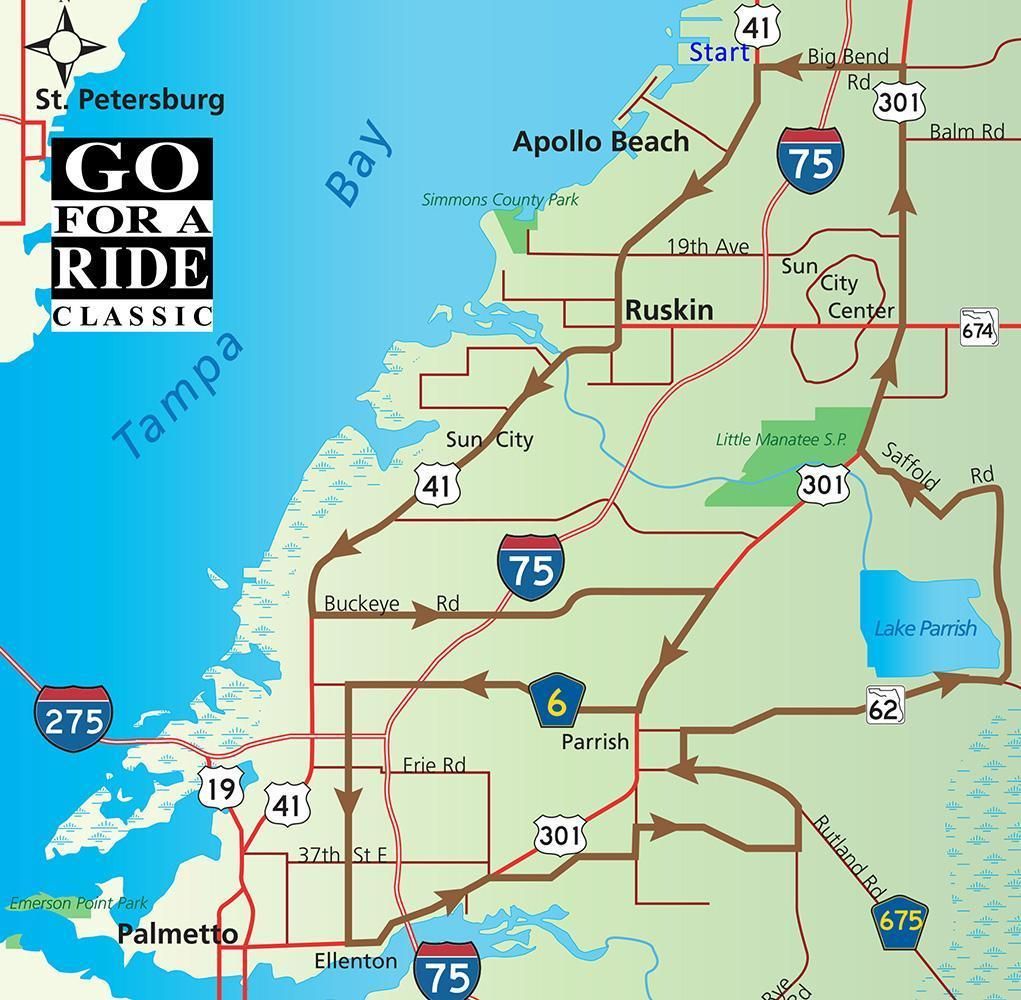
This ride starts in Apollo Beach and winds southward to Ellenton and back. The roads are mostly flat and straight with new subdivisions crowding out the farmland. At the southern end of this ride is a host of restaurants and such around the outlet mall. Enjoy a break before heading back out into the countryside for the return ride. 

Road Name - Direction - Miles

  1. Start at Intersection of US 41 and Big Bend Rd
  2. US 41 - South - 15.8 Miles
  3. Buckeye Rd - Left - 8.6 Miles
  4. US 301 - Right - 3.0 Miles
  5. Moccasin Wallow Rd - Right - 6.2 Miles
  6. 36" Ave/Ellenton/Gillette - Left - 5.4 Miles
  7. US 301 - Left - 3.6 Miles
  8. Old Tampa Rd - Right - 3.3 Miles
  9. Fort Hamer Rd - Left - 0.6 Miles
  10. Golf Course Rd - Right - 3.4 Miles
  11. N Rye Rd - Left - 0.5 Miles
  12. CR 675/Rutland Rd - Left - 2.8 Miles
  13. Spencer Parrish Rd - Right - 0.8 Miles
  14. SR 62 - Right - 7.3 Miles
  15. Saffold Rd - Left - 7.3 Miles
  16. Saffold Rd/Dug Creek - Left - 4.8 Miles
  17. US 301 - Right - 3.6 Miles
  18. Big Bend Rd - Left - 8.2 Miles
  19. Return to starting point

Download PDF

Continue reading