
Gainesville Loop Scenic Ride

Gainesville Loop

Scenic Ride 23

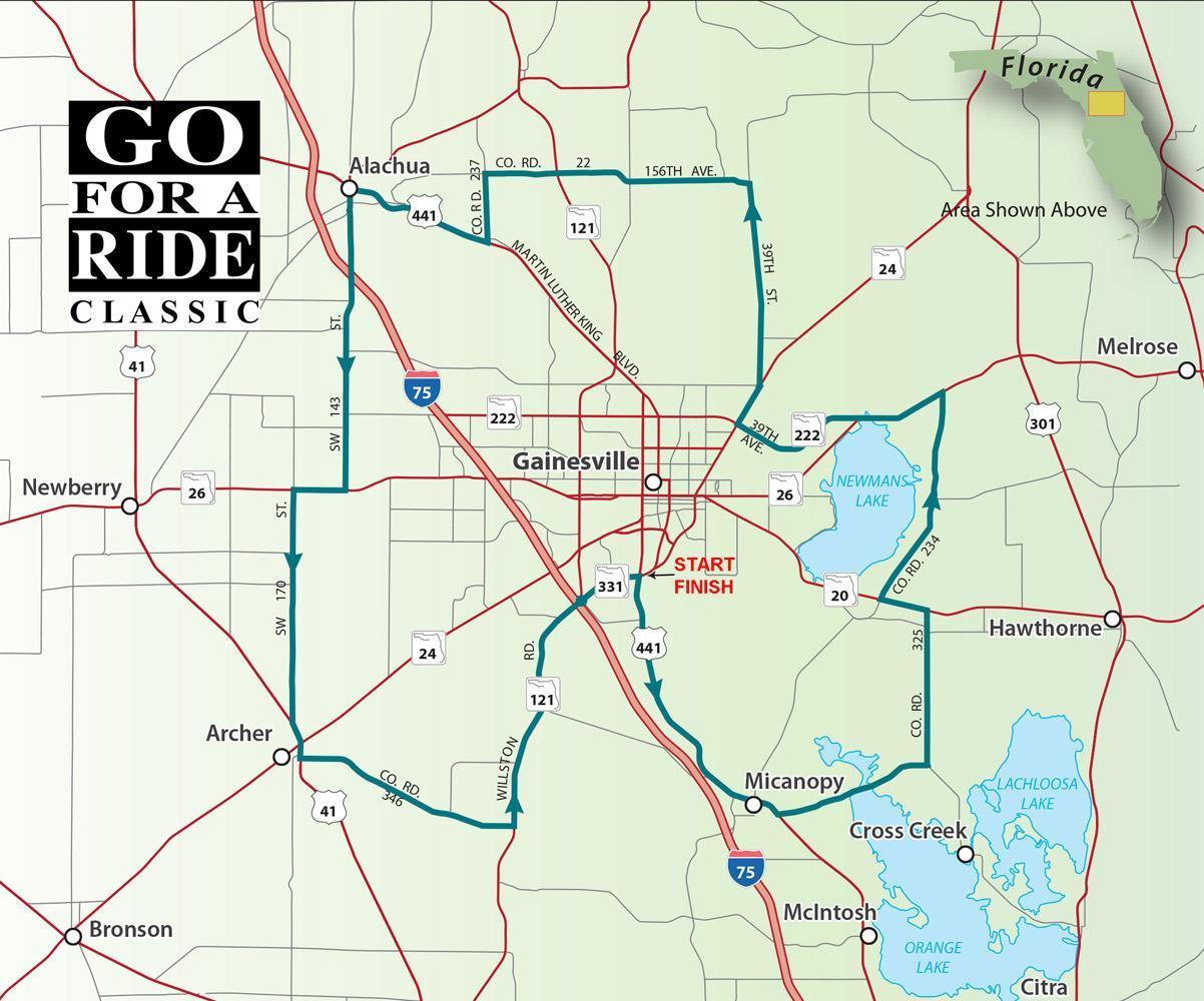
You don't have to be a Gator fan to enjoy this ride which circles through the woodlands and prairies surrounding Alachua county's largest city. The route includes a portion of the Old Florida Heritage highway as you roll across Paynes Prairie Reserve. Time seems to have stood still in Micanopy, a small town with stately mansions and historic homesteads. You'll find some history, nature, and culture all in one ride.

Road Name - Direction - Miles

  1. Start at intersection of 1-75 (Exit 382) and SW Williston Rd
  2. SR 331/SW Williston Rd - East - 2.0 Miles
  3. US 441/SW 130 ST - Right - 8.7 Miles
  4. CR 346 - Left - 9.7 Miles
  5. CR 325 - Left - 4.9 Miles
  6. SR 207SE Hawthore Rd - Left - 1.5 Miles
  7. CR 234 - Right - 7.1 Miles
  8. SR 26 - Left - 2.9 Miles
  9. SR 222 - Straight - 4.4 Miles
  10. SR 24/Waldo Rd - Right - 1.4 Miles
  11. CR 232/NE 53" Ave Left - 0.1 Miles
  12. CR 225/NE 39 St - Right - 6.4 Miles
  13. NW 156 Ave - Left - 8.5 Miles
  14. CR 237 - Left - 2.2 Miles
  15. SR 20/ML King Blvd - Right - 4.8 Miles
  16. CR 241/NW 140 SI - Left - 9.7 Miles
  17. SR 26/W Newberry Rd - Right - 1.6 Miles
  18. CR 241/SW 170 St - Left - 7.5 Miles
  19. US 41/N University Ave - Left - 1.1 Miles
  20. CR 346 - Left - 7.3 Miles
  21. SR 121/5W Williston Rd - Left - 8.0 Miles
  22. Return to start

Download PDF

Goethe State Forest Scenic Ride

Goethe State Forest Ride

Scenic Ride 24

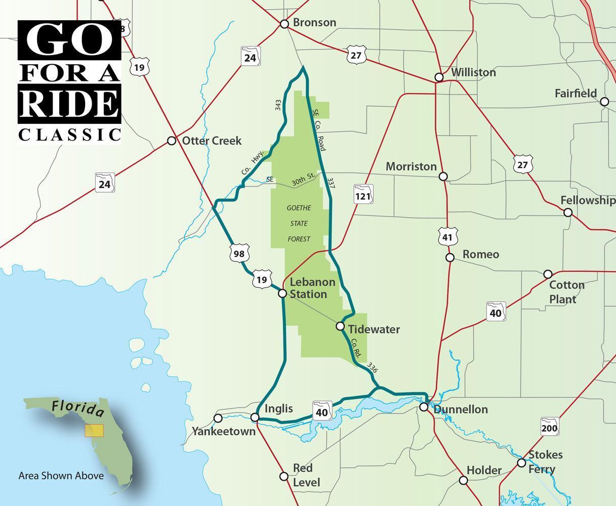
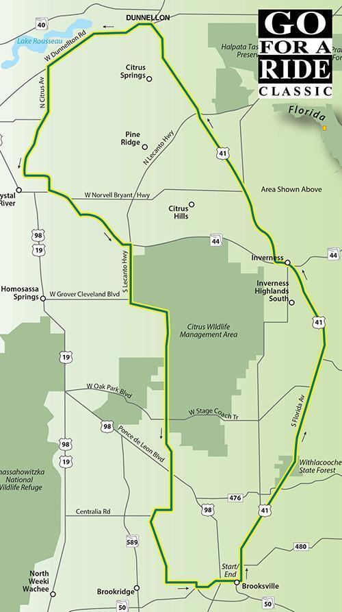
The Goethe State Forest in Levy County was established in 1992. Tree-lined roadways meander through one of the largest tracts of contiguous, old-growth longleaf pine flatwoods in the state and is home to black bears, fox squirrels, and bald eagles. The forest is open during daylight hours for hiking, fishing, picnics, and horseback riding. Gas up before leaving Dunnellon.

Direction - Road Name - Miles

  1. Start in downton Dunnellon
  2. CR 40/Pennsylvania Ave - West - 0.2 Miles
  3. CR 40/Cedar - Right - 0.6 Miles
  4. W Hwy 40 - Straight - 3.3 Miles
  5. CR 336 - Right - 5.7 Miles
  6. CR 337 - Right - 20.1 Miles
  7. CR 343 - Left - 10.2 Miles
  8. CR 326 - Right - 3.2 Miles
  9. US 19/US 98 S - Left - 18.0 Miles
  10. CR40 E - Left - 13.8 Miles
  11. Returns to Dunnellon

Download PDF

Christmas Scenic Ride

CHRISTMAS

Scenic Ride 25

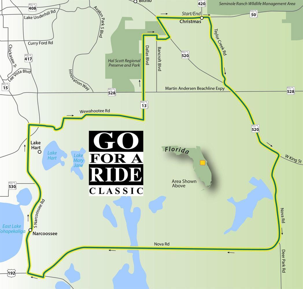
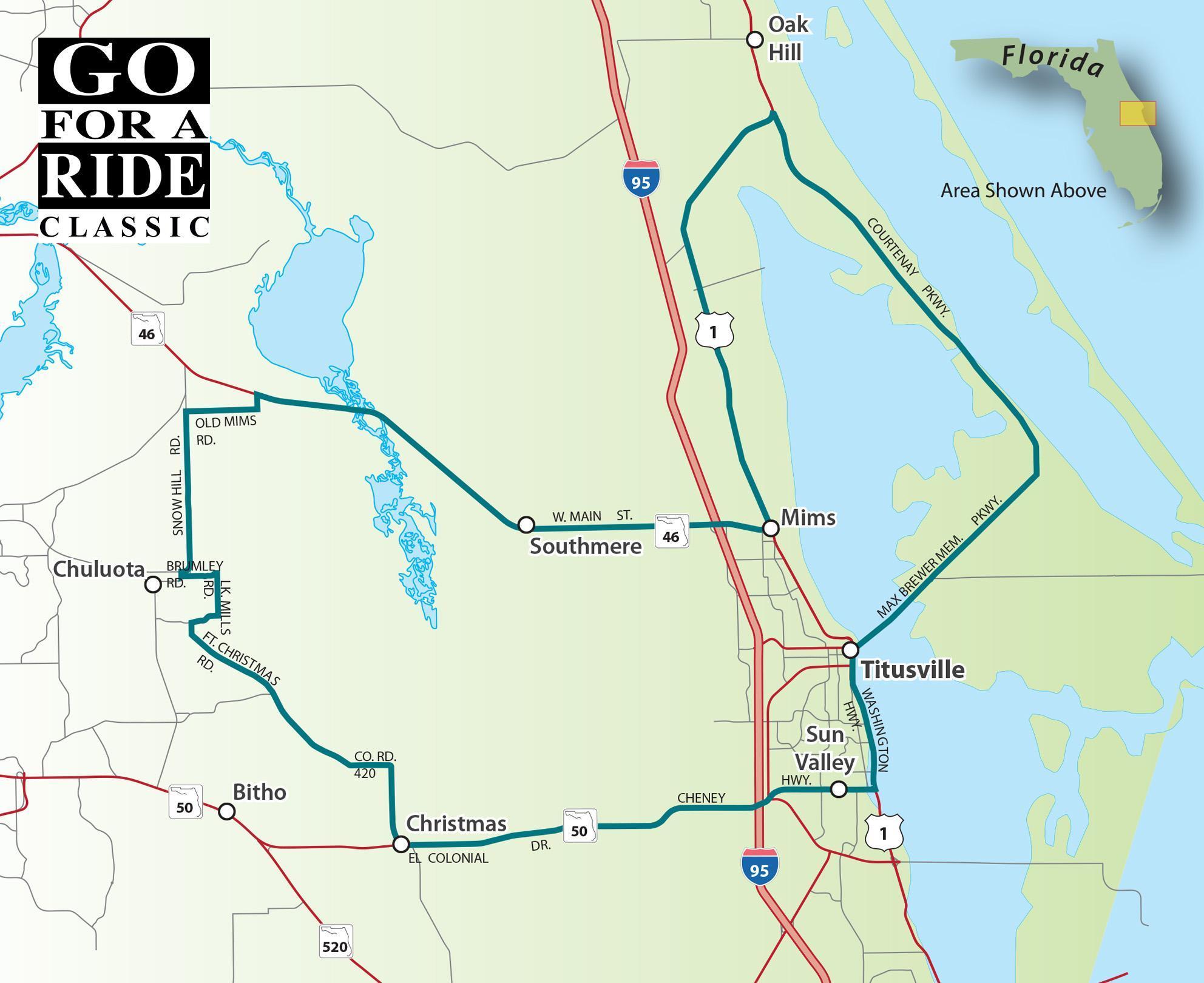
When it was founded in 1837, the area was called Fort Christmas but was shortened to Christmas when the Post Office opened in 1892. The Post Office is extremely busy during the holiday season with those seeking the coveted Christmas, FL postmark on their holiday cards and letters.

This route does include some toll roads. You can use your Sunpass or the state will bill you by plate number.

Road Name - Direction - Miles

  1. Start in Christmas on Hwy 50 at the Post Office
  2. SR 50 - East - 0.5 Miles
  3. Taylor Creek Rd - Right - 5.4 Miles
  4. SR 520E - Left - 7.3 Miles
  5. Nova Rd - Right - 26.5 Miles
  6. US 192/US 441 - Right - 1.3 Miles
  7. S Narcoosee Rd - Right - 11.2 Miles
  8. FL 417N (toll) - Right - 3.4 Miles
  9. Exit 26 to Cocoa - Right -1.0 Miles
  10. FL 528E (toll) - Merge - 7.5 Miles
  11. Exit 24 Dallas Blvd - Right - 0.3 Miles
  12. Dallas Blvd/SR 13 - Left - 4.6 Miles
  13. Majestic St - Right - 1.0 Miles
  14. Bancroft Blvd - Right - 0.4 Miles
  15. Maxim Pkwy - Left - 1.1 Miles
  16. SR 520 - Left - 1.7 Miles
  17. SR SOE - Right - 3.5 Miles
  18. Returns to starting point

Download PDF

Swapmeet Swamp Ride

SWAPMEET SWAMP

Scenic Ride 26

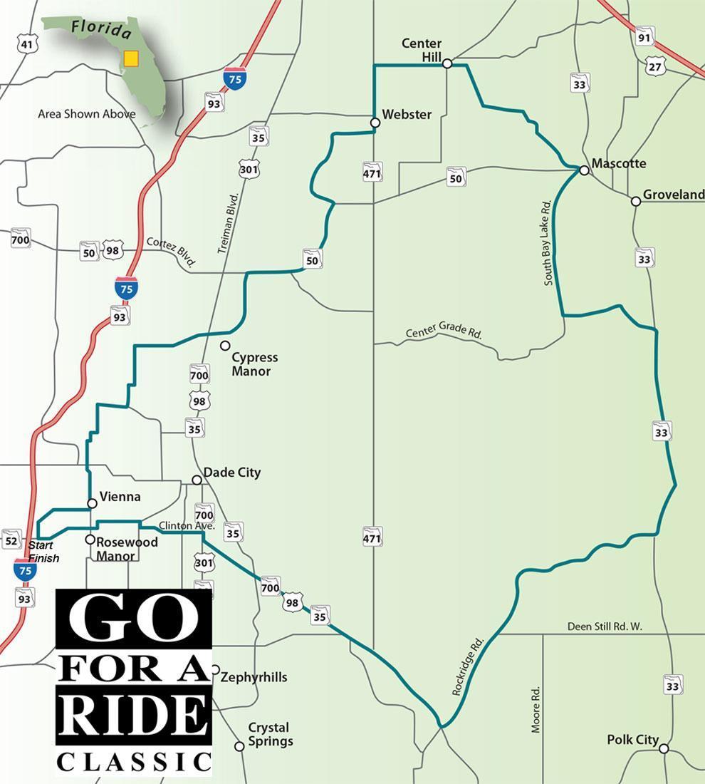
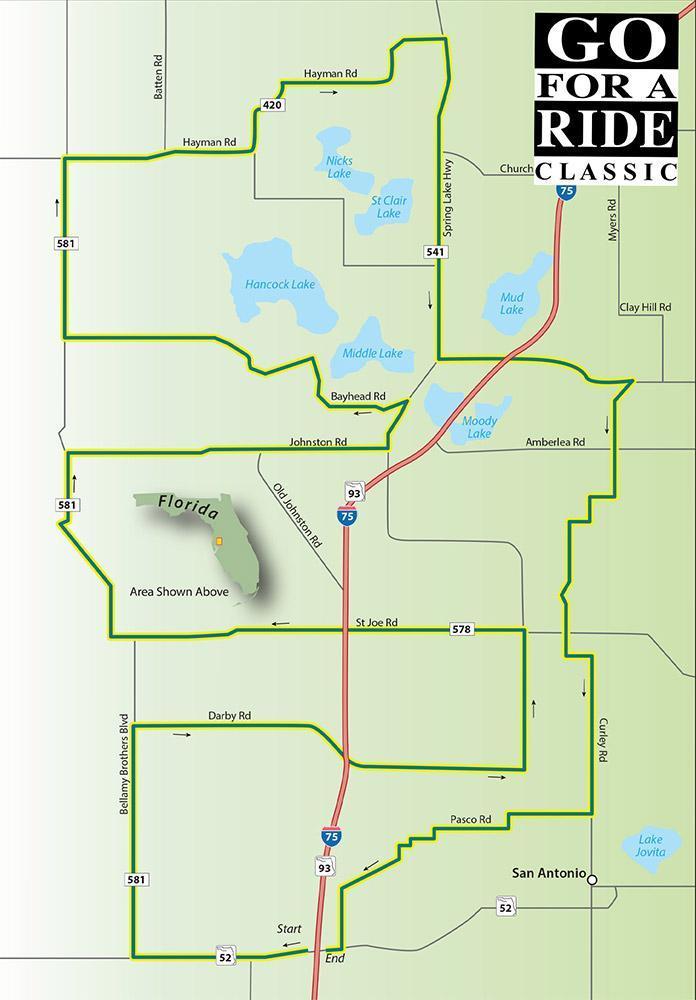
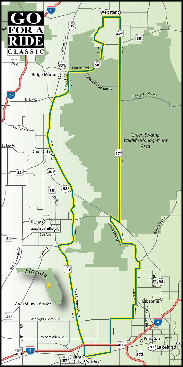
Central Florida has a lot to offer when it comes to riding. There are still many areas that have yet to be developed where you can cruise for miles enjoying the rural views. This route was designed as a scenic ride to the Webster Flea Market and then a slightly longer route through the Green Swamp to return. Pick any section of the route and you're sure to enjoy it. 

Road Name - Direction - Miles

  1. Start on SR 52 just east of I-75, near the Flying!
  2. Pasco Rd - North - 2.4 Miles
  3. CR 577/Curley Rd - Left - 2.2 Miles
  4. Jessamine Rd - Straight - 3.0 Miles
  5. James Rd - Right - 0.2 Miles
  6. Blanton Rd - Right - 1.3 Miles
  7. CR 575/Trilby Rd - Left - 11.0 Miles
  8. SR 50 - Right - 6.4 Miles
  9. CR 478A - Left - 6.3 Miles
  10. SR 471/Market Blvd - Left - 3.3 Miles
  11. SR 48E - Right - 3.8 Miles
  12. CR 469 - Straight - 2.8 Miles
  13. CR 728/Tuscanooga - Left - 5.6 Miles
  14. SR 50/Myers Blvd - Left - 0.3 Miles
  15. CR 565/S Bay Lake - Right - 7.4 Miles
  16. Lake Erie Rd - Left - 5.0 Miles
  17. SR 33 - Right - 10.1 Miles
  18. Greenpond Rd - Right - 4.0 Miles
  19. Rockridge Rd - Straight - 12.0 Miles
  20. SR 35/US98 - Right - 14.7 Miles
  21. US 301/US 90 - Right - 0.3 Miles
  22. CR 52A/Clinton Ave - Left - 3.1 Miles
  23. CR 52A/Prospect Rd - Right - 0.3 Miles
  24. SR 52 - Left - 5.4 Miles
  25. Returns to Starting point

Download PDF

The A To Z Ride

THE A to Z RIDE

Scenic Ride 27

Touring three central Florida counties, this ride takes you along parts of Florida's historic Cracker Trail. Start out in Arcadia, which was once a thriving gateway to the South Florida trading outposts.

The route heads westward skirting along the boundary for the Myakka River State Park. The roads are flat, with mostly straight stretches interrupted by a few gentle curves. SR 64 is considered part of the Florida Cracker Trail which recognizes the important roles the cattle and horse industry played in this area's development.

The leisurely ride winds up in Zolfo Springs which was named by a group of Italian pioneers in the early 1 B00's when they were dredging the Peace River and came upon a nearby spring which emitted a strong sulfur odor. Zolfo is Italian for sulfur.

Road Name - Direction - Miles

  1. Start in Arcadia at the intersection of US 17 & SR 70
  2. SR 70 - West - 13.4 Miles
  3. County In Rd - Left - 1.1 Miles
  4. Clay Gully Rd - Straight - 12.9 Miles
  5. Myakka Rd - Right - 2.6 Miles
  6. Jomar Rd - Slight Left - 0.1 Miles
  7. Myakka Rd - Right - 1.0 Miles
  8. Verna Rd - Straight - 3.6 Miles
  9. SR 70 East - Right - 7.1 Miles
  10. Wauchula Rd - Left - 10.4 Miles
  11. SR 64 East - Right - 4.2 Miles
  12. CR 665 - Right - 5.6 Miles
  13. Goose Pond Rd - Left - 6.6 Miles
  14. Bridges Rd - Straight - 2.0 Miles
  15. Murphy Rd/CR 663 - Left - 5.5 Miles
  16. SR 64 - Right - 5.1 Miles

Download PDF

Mt Dora To Zellwood Loop

MT. DORA to
ZELLWOOD LOOP

Scenic Ride 28

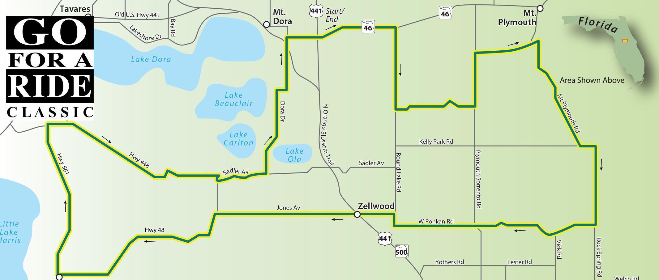
Finding scenic rides near Orlando is a challenge with all of the tourist sprawl. We did find a few good backroads in the area near Mt Dora and Zellwood. The ride itself will only take you an hour but that gives you time to detour to Wekiwa Springs State Park or sample the sweet tastings at the Zellwood Sweet Corn Festival in May of each year. And, no matter what time of year you make the ride, the shops and restaurants in Mt Dora are open for business.

Road Name - Direction - Miles

  1. Start east of Mt Dora at US 441 & SR 46 Intersection
  2. SR 46 - East - 1.9 Miles
  3. Round Lake Rd - Right - 2.0 Miles
  4. Ondich Rd - Left - 2.1 Miles
  5. CR 437/Plymouth Sorrento Rd - Left - 1.4 Miles
  6. Adair Dr - Right - 1.4 Miles
  7. Troon Ave - Right - 0.2 Miles
  8. CR 435/Mt Plymouth Rd - Right - 2.9 Miles
  9. w Kelly Park Rd - Left - 0.5 Miles
  10. CR 435/Rock Springs Rd - Right - 2.0 Miles
  11. E Ponkan Rd - Right - 5.2 Miles
  12. N Round Lake Rd - Right - 0.3 Miles
  13. W Jones Ave - Left - 4.2 Miles
  14. Duda Rd - Straight - 0.3 Miles
  15. CR 448A - Left - 0.5 Miles
  16. CR 48 - Right - 4.3 Miles
  17. CR 561/Monroe St - Right - 3.9 Miles
  18. CR 448 - Right - 6.0 Miles
  19. Dora Dr - Left - 2.3 Miles
  20. Beauclair Ave - Right - 0.2 Miles
  21. S Clayton St - Left - 1.3 Miles
  22. E 1 Ave - Right - 0.7 Miles
  23. Returns to starting point

Download PDF

Heartland Ride #2

Heartland Ride #2

Scenic Ride 29

The area northwest of Lake Okeechobee is known as Florida's Heartland. Citrus groves, farm fields, and cattle ranches cover this area. There are quaint and historic towns like Arcadia, Avon Park and Wauchula along the route with excellent opportunities for dining and sightseeing. Highlands Hammock State Park is one of the state's oldest and Lake Placid's business district has more than 40 murals depicting everything from dinosaurs to the Last Supper. 

Road Name - Direction - Miles

  1. Start at intersection of SR 70 & US 27
  2. US 27 - North - 9.7 Miles
  3. CR 17 - Right - 6.7 Miles
  4. US 98 - Left - 0.5 Miles
  5. CR 178 - Right - 3.4 Miles
  6. CR 623/Airport Rd - Left - 2.8 Miles
  7. SE Lakeview Dr - Left - 1.1 Miles
  8. Keep Right at the fork in the road
  9. US 27/0S 08 - Straight - 1.7 Miles
  10. CR 634/Hammock Rd - Left - 8.0 Miles
  11. Parnell Rd - Right - 1.8 Miles
  12. Steve Roberts Special - Left - 10.8 Miles
  13. SR 64 - Left - 0.8 Miles
  14. US 17/SR 35 - Right - 10.3
  15. FL 664/NW County Line - Right - 12.1
  16. w Bereah Rd - Left - 2.4
  17. Avon Park Cutoff - Right - 4.8
  18. US 27/US 98 - Right - 6.4
  19. SR 64/W Main St - Right - 6.8
  20. SR 671/Parnell Rd - Left - 10.8
  21. Crossing SR 66 - Straight
  22. Crewsville Rd - Straight - 9.3
  23. Sweetwater Rd - Left - 5.9
  24. US 17/SR 35 - Left - 14.4
  25. SR 70/E Magnolia St - Left - 32.7
  26. Return to starting point

Download PDF

48 Miles Of Smiles

48 Miles Of Smiles

Scenic Ride 31

Draw a box on the map using US301, SR52, US41, and SR50 as the borders. Inside that box, you'll find some of Florida's most satisfying backroads.

Road Name - Direction - Miles

  1. Starts at intersection of -75 and SR52
  2. SR 52 West - West - 1.9 Miles
  3. Bellamy Brothers Blvd - Right - 2.6 Miles
  4. Darby Rd - Right - 4.5 Miles
  5. Scharber Rd - Left -1.5 Miles
  6. St Joe Rd - Left - 4.3 Miles
  7. Bellamy Brothers Blvd - Right - 2.5 Miles
  8. Johnston Rd - Right - 3.6 Miles
  9. Lake lola Rd - Left - 0.6 Miles
  10. Bayhead Rd - Left - 4.4 Miles
  11. Bellamy Brothers Blvd - Right - 1.0 Miles
  12. Culbreath Rd - Straight - 1.0 Miles
  13. Hayman Rd - Right - 5.3 Miles
  14. Spring Lake Hwy - Right - 2.5 Miles
  15. lake lola Rd - Straight - 1.0 Miles
  16. Blanton Rd - Left - 2.2 Miles
  17. James Rd - 2nd Right - 0.2 Miles
  18. Jessamine Rd - Left - 3.0 Miles
  19. Curley Rd - Straight - 2.3 Miles
  20. Pasco Rd - Right - 3.9 Miles
  21. SR 52 - Right - 0.2 Miles
  22. Retums to starting point

Download PDF

Lovely Scenic Ride

Lovely Scenic Ride

Scenic Ride 32

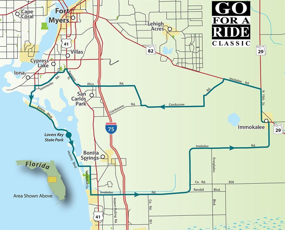
This tour starts beachside just south of Fort Myers Beach at the entrance to Lovers Key State Park. The popular park is home to manatees, dolphins, and bald eagles.

Road Name - Direction - Miles

  1. Ride starts at Love Key State Park
  2. Estero Blvd - South - 2.6 Miles
  3. Hickory Blvd - Straight - 2.1 Miles
  4. Bonita Beach Rd - Left - 1.6 Miles
  5. CR 856A/Vanderbilt Dr - Right - 4.0 Miles
  6. CR 846/Immokalee Rd Loft - 33.9 Miles
  7. (The route has some turns - just follow to Immokalee)
  8. W Main SUSR 29 - Left - 5.4 Miles
  9. Immokalee Rd/SR 82 W - Left - 5.3 Miles
  10. Corkscrew Rd/CR 850 - Left - 14.1 Miles
  11. Alico Rd - Right - 11.1 Miles
  12. Tamiami THUS 41 - Right - 2.7 Miles
  13. Gladiolus Dr - Left - 1.2 Miles
  14. Summerlin Rd/CF 869 - Left - 1.9 Miles
  15. San Carlos Blvd - Left - 3.1 Miles
  16. Estero Blvd - Left - 7.1 Miles
  17. Return to starting point

Download PDF

Cool Springs Ride

Cool Springs Ride

Scenic Ride 33

Summers are HOT in Florida but you can find some relief at two of Florida's cool natural springs. Rainbow Springs is the starting point on a tour past farms and forests on this route to lchetucknee State Park. Both parks offer swimming, tubing, nature trails, and more. You can even camp at Rainbow Springs. Don't forget to pack those swimsuits!

Road Name - Direction - Miles

  1. Start at Rainbow Springs State Park near Dunellon
  2. SW 180th Ave - North - 4.6 Miles
  3. SR 40 E - Right - 7.7 Miles
  4. NW 110th Ave - Left - 4.4 Miles
  5. US 27 - Right - 0.5 Miles
  6. NW Hwy 225 - Left - 3.2 Miles
  7. CR 326 - Left - 9.0 Miles
  8. SE 32nd Place - Left - 0.4 Miles
  9. US 41 - Right - 0.3 Miles
  10. CR 326/SE 30th St - Left - 8.7 Miles
  11. CR 337 - Right - 9.3 Miles
  12. SR 337 - Straight - 0.1 Miles
  13. NE CR 337/Penn. Ave- Straight - 1.7 Miles
  14. US 27 ALT/E Hathaway - Left - 3.7 Miles
  15. CR 339 - Right -12.4 Miles
  16. US 129 - Right - 0.9 Miles
  17. SR 47/Trenton Blvd - Right - 17.5 Miles
  18. CR 138 - Left - 8.1 Miles
  19. US 129 - Right - 4.2 Miles
  20. US 27 - Right - 5.1 Miles
  21. Arrive at Ichetucknee Springs State Park

Download PDF

Clermont Cruise

Clermont Cruise

Scenic Ride 34

Known as the "Gem of the Hills", Clermont is home to the Florida Citrus Tower, one of Florida's first tourist attractions, which was opened in 1956.

Road Name - Direction - Miles

  1. Start in Clermont at SR 50 & CR 561 (12th Street)
  2. 12th SUCR 561 - South - 0.4 Miles
  3. W Minnehaha/CR 561 - Right - 3.9 Miles
  4. Log House Rd - Left - 0.8 Miles
  5. Lakeshore Dr - Left - 22 Miles
  6. Hammock Ridge Rd - Straight - 0.4 Miles
  7. Lake Louisa Rd Right 3.3 Miles
  8. US 27 Right - 8.5 Miles
  9. CR 474 - Right - 8.6 Miles
  10. SR 33 - Right - 2.3 Miles
  11. CR 561 - Right - 5.9 Miles
  12. Florida Boy's Ranch Rd - Left - 3.5 Miles
  13. SR 33 - Right - 1.6 Miles
  14. Pine Island Rd - Right - 2.2 Miles
  15. Montevista Rd - Left - 4.6 Miles
  16. SR 50 - Right - 3.7 Miles
  17. Returns you to the starting point

Download PDF

Easy As A-B-C

EASY AS A-B-C RIDE

Scenic Ride 35

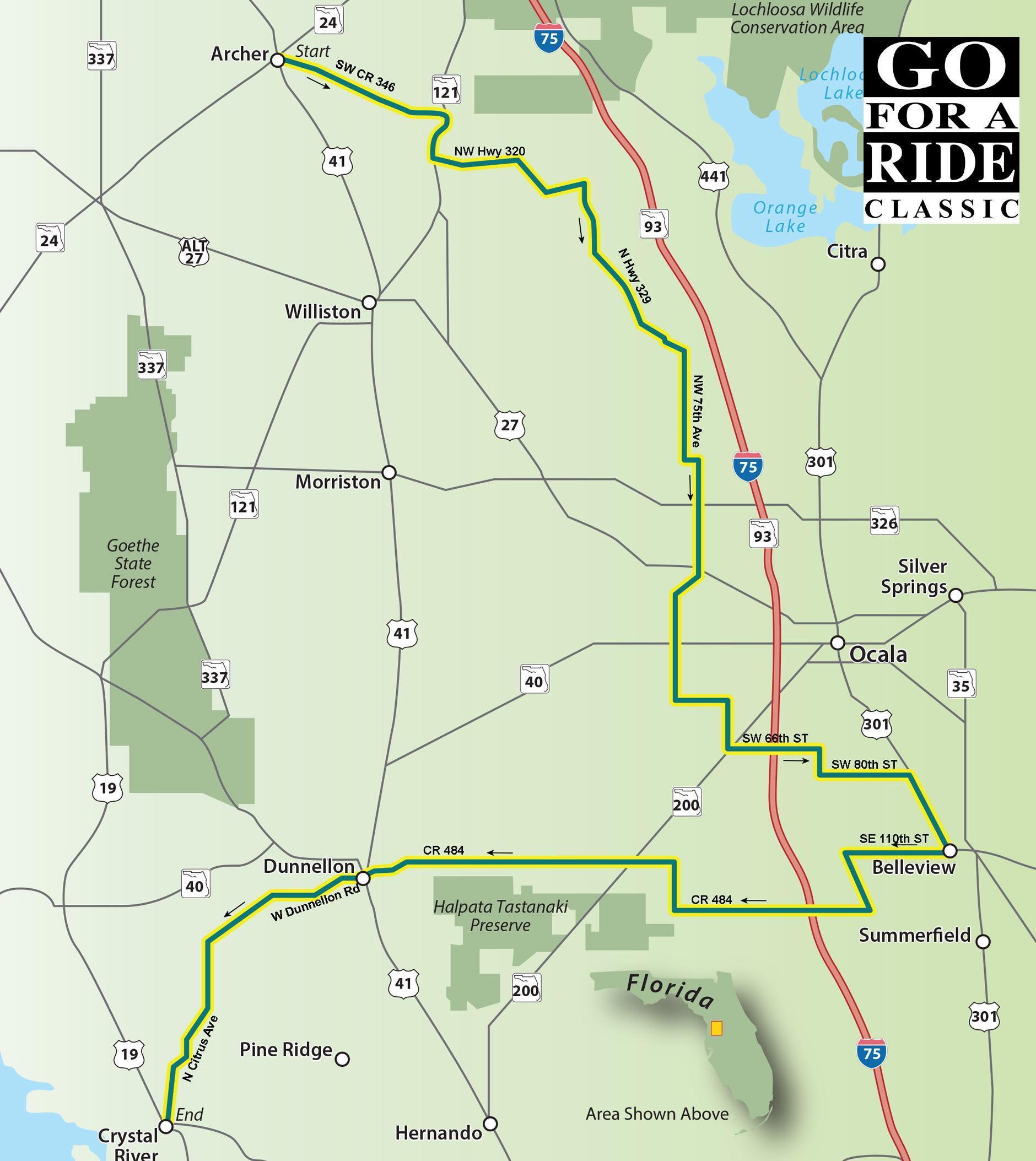
This ride begins in Archer, then meanders through Belleview before heading towards the Gulf and ending in Crystal River taking you through the heart of central Florida. Small towns, horse farms, and quaint country roads combine to make this a relaxing ride.

Road Name Direction Distance Total

  1. Starting in Archer at the corner of SR 24 and US 41
  2. US 41 - South - 0.5 Miles
  3. SW CR 346 - Left - 7.3 Miles
  4. SR 121 S - Right - 1.9 Miles
  5. NW Hwy 320 - Left - 6.7 Miles
  6. N Hwy 329 - Right - 8.4 Miles
  7. NW 75 Ave - Right - 4.4 Miles
  8. NW 100 St - Straight - 0.5 Miles
  9. NW 70' Ave - Straight - 6.6 Miles
  10. NW 80 Ave - Straight - 4.0 Miles
  11. SW 38" St - Left - 2.0 Miles
  12. SW 60 Ave - Right - 2.3 Miles
  13. SR 200 - Left - 0.4 Miles
  14. SW 66 St - Right - 3.4 Miles
  15. SW 19 Ave Rd - Straight - 1.1 Miles
  16. SW 80 St - Left - 3.6 Miles
  17. US 27/US 301 - Right - 3.3 Miles
  18. SE 110 St - Right - 4.2 Miles
  19. CR 475 S - Left - 2.6 Miles
  20. SE 135" SUCR 484 - Right - 22.3 Miles
  21. S Williams SVUS 41 - Left - 0.5 Miles
  22. W Dunnellon Rd - Right - 7.0 Miles
  23. N Citrus Ave - Left - 7.7 Miles
  24. Reach your destination Crystal River

Download PDF

Leesburg Bellview Loop

LEESBURG BELLVIEW LOOP

Scenic Ride 36

The countryside around Leesburg offers some great riding opportunities. The roads wind around the many waterways in this area give credence to the name "Lake County".

Road Name - Direction - Miles

  1. Start in Leesburg at E Dixie Ave(SR 44) & US 441
  2. US 441 - East - 1.8 Miles
  3. CR 44 East - Left - 10.1 Miles
  4. CR 452 - Left - 10.8 Miles
  5. SR 42 - Left - 8.9 Miles
  6. SR 25 N/Ocala Rd - Right - 12.1 Miles
  7. SE 110 St - Left - 0.2 Miles
  8. SE Hames Rd - Straight - 0.2 Miles
  9. SE Magnolia Rd - Left - 0.1 Miles
  10. US 301- Left - 9.2 Miles
  11. CR 466A - Left - 7.6 Miles
  12. CR 468/Rose Ave - Right - 3.5 Miles
  13. Main Street - Left - 3.2 Miles
  14. Cloud St - Left - 0.1 Miles
  15. US 441 - Right - 0.4 Miles
  16. Return to starting point

Download PDF

Christmas Ride Part 2

Christmas Ride Part 2

Scenic Ride 38

The town of Christmas was founded as a U.S. Army fort on December 25, 1837, during the Second Seminole War.

Rode Name - Direction - Miles

  1. Starts in Christmas at SR 50 & Fort Christmas Rd
  2. SR 50/E Colonial Dr - East - 13.7 Miles
  3. US 1/Washington Ave - Left - 4.1 Miles
  4. A. Max Brewer Pkwy - Right - 7.0 Miles
  5. Courtenay Pkwy N - Straight - 9.1 Miles
  6. Kennedy Pkwy/Shiloh Straight - 3.8 Miles
  7. US 1 - Left - 13.0 Miles
  8. SR 46/W Main St - Right - 15.6 Miles
  9. S Jungle Rd - Left - 0.4 Miles
  10. Old Mims Rd - Right - 2.0 Miles
  11. CR 13/Snow Hill Rd - Left - 4.7 Miles
  12. Avenue H - Left - 0.1 Miles
  13. Brumley Rd - Left - 1.0 Miles
  14. Lake Mills Rd - Right - 0.8 Miles
  15. Fort Christmas Rd - Left - 9.4 Miles
  16. Return to start

Download PDF

This Ride is Mine

This Ride is Mine

Scenic Ride 42

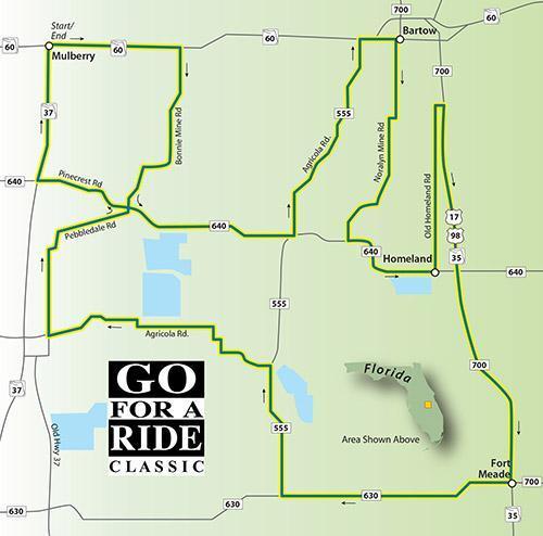
More than a century ago phosphate mining helped establish many of the small towns in central Florida. Most of those mines are no longer active but the roadways that snake around the pits and reservoirs left behind are the perfect remedy for crowded road fever.

Road Name - Direction - Miles

  1. Start in Mulberry @ intersection of SR60 and SR37
  2. SR 60 - East - 2.9 Miles
  3. Bonnie Mine Rd - Right -4.2 Miles
  4. CR 640/Pinecrest - Left -3.9 Miles
  5. CR 555/Agricola Rd - Left - 4.9 Miles
  6. SR 60/Main St - Right - 0.3 Miles
  7. W Main St - Right - 0.5 Miles
  8. S Floral Ave - Right - 1.8 Miles
  9. Noralyn Mine Rd - Left - 3.2 Miles
  10. CR 640 - Left - 2.5 Miles
  11. Old Homeland Rd - Left - 2.8 Miles
  12. S Kissingen Ave - Straight - 0.9 Miles
  13. Mann Rd - Right - 0.2 Miles
  14. US 17/US 98 - Right - 8.9 Miles
  15. CR 630 - Right - 5.3 Miles
  16. CR 555 - Right - 3.0 Miles
  17. Agricola Rd - Left - 5.8 Miles
  18. Old SR 37 - Right - 2.4 Miles
  19. Pebbledale Rd - Right - 1.8 Miles
  20. Pinecrest Rd - Left - 2.4 Miles
  21. SR 37 N - Right - 3.0 Miles
  22. Returns you to the starting point

Download PDF

US41 And Beyond

US41 and Beyond

Scenic Ride 43

If you followed US41 as far as it goes, you'd be in Michigan's Upper Peninsula. This ride gives you a small taste of this historic roadway with a ride through some quaint towns and scenic countryside.

Road Name - Direction - Miles

  1. Start in Brooksville @ N Broad St/US 41 and S 98
  2. US 41 - North - 38.7 Miles
  3. W Dunnellon Rd - Left - 6.9 Miles
  4. N Citrus Ave - Left - 6.9 Miles
  5. N Turkey Oak Dr - Left - 2.4 Miles
  6. SR 44 E - Left - 6.3 Miles
  7. S Lecanto Hwy/CR 491 - Right - 23.4 Miles
  8. Fort Dade Ave - Left - 1.7 Miles
  9. Cobb Rd/CR 485 - Right - 0.3 Miles
  10. Cortez Blvd/W Jefferson - Left - 1.7 Miles
  11. S Broad St/W Jefferson - Left - 0.8 Miles
  12. Return to the starting point

Download PDF

Florida National Cemetery Loop

Florida National Cemetery Loop

Scenic Ride 44

Even before Florida was granted statehood in 1845, the land in and around the Withlacoochee State Forest has been populated by farms and ranches. The area was home to a sugar mill during the Civil War and was a major contributor to Florida's citrus industry for many years. This month's ride starts at the Florida National Cemetery which is just off 1-75, north of Brooksville. Along with miles and miles of country back roads, you'll find cool places to stop for a break in and around Floral City and Brooksville.

Road Name - Direction - Miles

  1. Start in front of the Florida National Cemetery
  2. County Road 476B - North - 2.4 Miles
  3. CR 476E - Right - 1.6 Miles
  4. CR 625 - Left - 1.9 Miles
  5. SR 48 - Left - 5.1 Miles
  6. CR 575 - Left - 6.3 Miles
  7. CR 476/Lake Lindsay Rd - Right - 2.6 Miles
  8. CR 439/Istachatta Rd - Right - 7.3 Miles
  9. CR 48/E Bushnell Rd - Left - 1.7 Miles
  10. US 41/Florida Ave - Left - 1.3 Miles
  11. CR 480/Stagecoach Drive - Right - 4.2 Miles
  12. CR 581/Pleasant Grove Rd - Left - 6.2 Miles
  13. US 41/Broad St - Right - 3.9 Miles
  14. Mondon Hill Rd - Left - 0.5 Miles
  15. Jasmine Dr - Right - 0.9 Miles
  16. SR 50/Cortez Blvd - Left - 12.7 Miles
  17. US 301 - Left - 7.5 Miles
  18. CR 673 - Left - 4.1 Miles
  19. CR 476 - Straight - 0.8 Miles
  20. Returns to start of the ride.

Download PDF

Plant City/Webster Relay

Plant City/Webster Relay

Scenic Ride 48

This ride starts just down the street from the old train station in PC and winds northward through the strawberry fields before heading through the middle of the Green Swamp on what has to be one of the longest straightaways in Florida. The return route skirts around Dade City and Zephyrhills on your way back.

Download PDF

Here A Lake, There A Lake.

HERE A LAKE, THERE A LAKE.

Scenic Ride 46

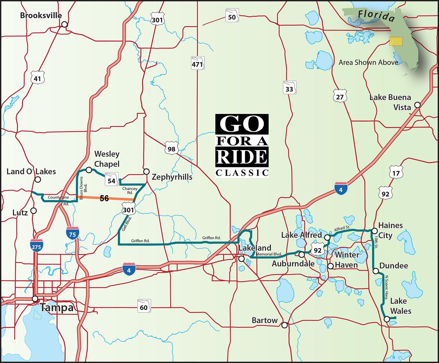
There are about two dozen Florida cities and towns with the word lake in their name. This ride hits a few of them. Start in Land O Lakes, then onto Lakeland and Lake Alfred, before ending in Lake Wales at the famous Bok Tower, which is not a water tower but contains a 60-bell carillon providing daily musical recitals.
Ride Update: SR56 didn't exist when this map was first published. The ride has been updated to avoid the congestion on SR54. Yes, we agree, this entire area is a traffic mess.

Download PDF

Coast To Coast

Coast To Coast

Scenic Ride 47

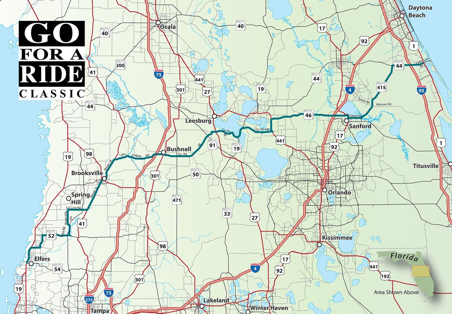
We've got a ride from New Port Richey to New Smyrna Beach with NO Interstate mileage. There are lots of interesting towns and stops along the way so take your time and enjoy the ride

Download PDF