Author: Judith

48 Miles Of Smiles

48 Miles Of Smiles

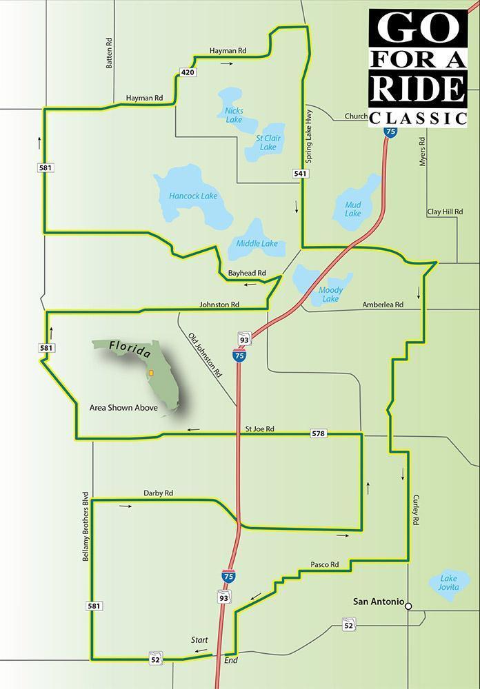
Scenic Ride 31

Draw a box on the map using US301, SR52, US41, and SR50 as the borders. Inside that box, you’ll find some of Florida’s most satisfying backroads.

Road Name – Direction – Miles

  1. Starts at intersection of -75 and SR52
  2. SR 52 West – West – 1.9 Miles
  3. Bellamy Brothers Blvd – Right – 2.6 Miles
  4. Darby Rd – Right – 4.5 Miles
  5. Scharber Rd – Left -1.5 Miles
  6. St Joe Rd – Left – 4.3 Miles
  7. Bellamy Brothers Blvd – Right – 2.5 Miles
  8. Johnston Rd – Right – 3.6 Miles
  9. Lake lola Rd – Left – 0.6 Miles
  10. Bayhead Rd – Left – 4.4 Miles
  11. Bellamy Brothers Blvd – Right – 1.0 Miles
  12. Culbreath Rd – Straight – 1.0 Miles
  13. Hayman Rd – Right – 5.3 Miles
  14. Spring Lake Hwy – Right – 2.5 Miles
  15. lake lola Rd – Straight – 1.0 Miles
  16. Blanton Rd – Left – 2.2 Miles
  17. James Rd – 2nd Right – 0.2 Miles
  18. Jessamine Rd – Left – 3.0 Miles
  19. Curley Rd – Straight – 2.3 Miles
  20. Pasco Rd – Right – 3.9 Miles
  21. SR 52 – Right – 0.2 Miles
  22. Retums to starting point

Download PDF

Continue reading

EASY AS A-B-C RIDE

EASY AS A-B-C RIDE

Scenic Ride 35

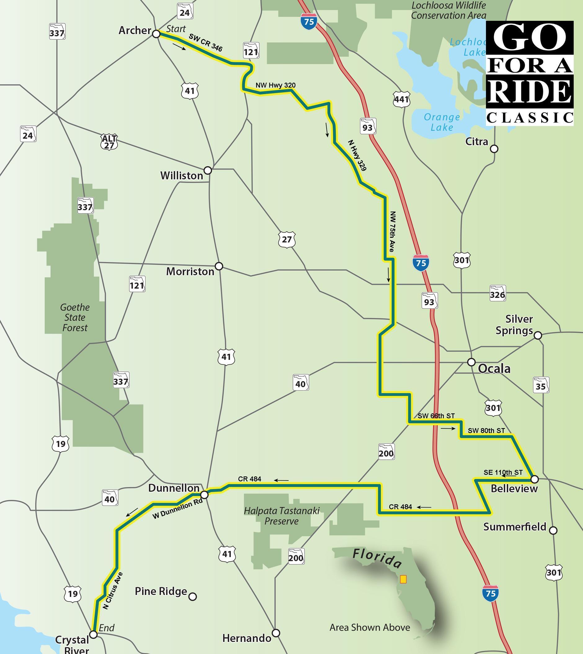
This ride begins in Archer, then meanders through Belleview before heading towards the Gulf and ending in Crystal River taking you through the heart of central Florida. Small towns, horse farms, and quaint country roads combine to make this a relaxing ride.

Road Name Direction Distance Total

  1. Starting in Archer at the corner of SR 24 and US 41
  2. US 41 – South – 0.5 Miles
  3. SW CR 346 – Left – 7.3 Miles
  4. SR 121 S – Right – 1.9 Miles
  5. NW Hwy 320 – Left – 6.7 Miles
  6. N Hwy 329 – Right – 8.4 Miles
  7. NW 75 Ave – Right – 4.4 Miles
  8. NW 100 St – Straight – 0.5 Miles
  9. NW 70′ Ave – Straight – 6.6 Miles
  10. NW 80 Ave – Straight – 4.0 Miles
  11. SW 38″ St – Left – 2.0 Miles
  12. SW 60 Ave – Right – 2.3 Miles
  13. SR 200 – Left – 0.4 Miles
  14. SW 66 St – Right – 3.4 Miles
  15. SW 19 Ave Rd – Straight – 1.1 Miles
  16. SW 80 St – Left – 3.6 Miles
  17. US 27/US 301 – Right – 3.3 Miles
  18. SE 110 St – Right – 4.2 Miles
  19. CR 475 S – Left – 2.6 Miles
  20. SE 135″ SUCR 484 – Right – 22.3 Miles
  21. S Williams SVUS 41 – Left – 0.5 Miles
  22. W Dunnellon Rd – Right – 7.0 Miles
  23. N Citrus Ave – Left – 7.7 Miles
  24. Reach your destination Crystal River

Download PDF

Continue reading

US41 and Beyond

US41 and Beyond

Scenic Ride 43

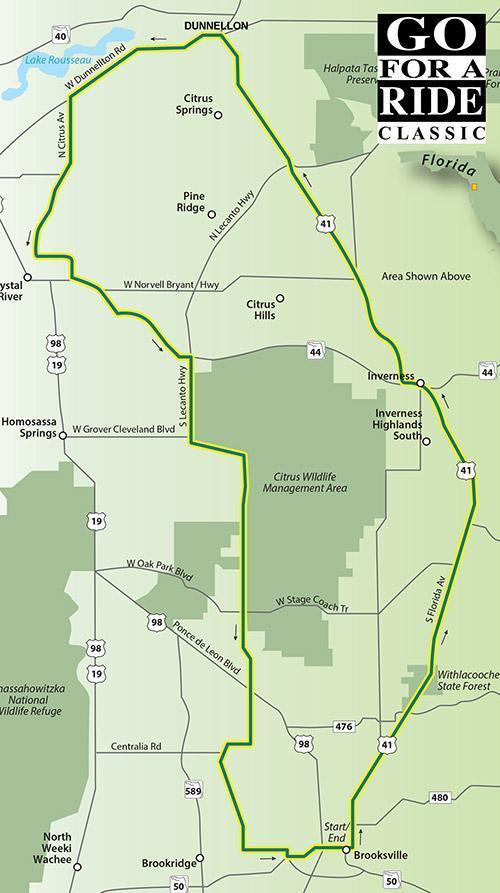
If you followed US41 as far as it goes, you’d be in Michigan’s Upper Peninsula. This ride gives you a small taste of this historic roadway with a ride through some quaint towns and scenic countryside.

Road Name – Direction – Miles

  1. Start in Brooksville @ N Broad St/US 41 and S 98
  2. US 41 – North – 38.7 Miles
  3. W Dunnellon Rd – Left – 6.9 Miles
  4. N Citrus Ave – Left – 6.9 Miles
  5. N Turkey Oak Dr – Left – 2.4 Miles
  6. SR 44 E – Left – 6.3 Miles
  7. S Lecanto Hwy/CR 491 – Right – 23.4 Miles
  8. Fort Dade Ave – Left – 1.7 Miles
  9. Cobb Rd/CR 485 – Right – 0.3 Miles
  10. Cortez Blvd/W Jefferson – Left – 1.7 Miles
  11. S Broad St/W Jefferson – Left – 0.8 Miles
  12. Return to the starting point

Download PDF

Continue reading

Ride Around The Big Water

Ride Around The Big Water

Scenic Ride 37

Lake Okeechobee was given the name Big Water by the Seminole tribe. It’s the second-largest freshwater lake in the country and Florida wouldn’t have become Florida without this source of the precious liquid.

Road Name – Direction – Miles

  1. Starts in LaBelle at SR 28 & SR 80
  2. SR 80 – East – 22.4 Miles
  3. SR 80/SR 25/US 27 Slight – Right – 24.8 Miles
  4. SR 80/Palm Beach Rd – Left – 7.0 Miles
  5. US 98/US 441/SR 15 – Straight – 44.6 Miles
  6. To Okeechobee
  7. SR 78 – Straight – 34.2 Miles
  8. To Moore Haven
  9. SR 78/SR 25 – Right – 14.5 Miles
  10. SR 29 – Left – 14.0 Miles
  11. Return to start.

Download PDF

Continue reading

Destination Conch Republic

Destination Conch Republic

Scenic Ride 40

Key West is a very unique place. The waterfront setting, the open-minded attitude, and the party mindset combine to make it an ideal destination when you’re looking to kick back and relax. Getting there isn’t very difficult as there’s only one road into and out of the Florida Keys, US1 which is also known as the Overseas Highway. The ride can be done in a few hours or it can turn into a week-long excursion as you explore the small towns and attractions along the way. Enjoy the ride and all that the Florida Keys have to offer, but remember, you gotta go home one of these days. Or do you?

Road Name – Direction – Miles

  1. Start in Miami at US 41 and SR 97 intersection.
  2. SR 997/Krome Ave – South – 22.4 Miles
  3. US 1 – Right – 0.2 Miles
  4. Old Card Sound Road – Left – 16.7 Miles
  5. (Toll Bridge on this route – $1.50 Sunpass/$2.50 via license plate
  6. SR 905 – Right – 9.2 Miles
  7. US 1 – Left – 102 Miles
  8. Arrive in Key West. Put your toes in the sand and enjoy.

Download PDF

Continue reading

MARCO ISLAND

MARCO ISLAND

Scenic Ride 16

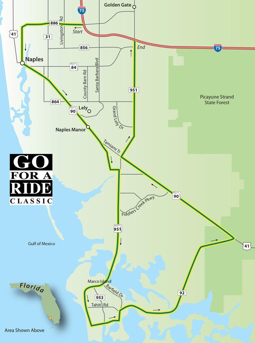
Heading through Naples on 1-75? Get off the super slab and check out the southwest corner of the state. This ride gives you a taste of Naples and a tour of scenic Marco Island. There are beautiful coastal views as you roll through marshlands and past a few mansions along this leisurely ride. Ride safe!

Road Name – Direction – Miles

  1. Start in Naples at 1-75 and Golden Gate Pkwy
  2. Golden Gate Pkwy – West – 3.4
  3. Goodette-Frank Rd – Left – 2.0
  4. Tamiami TrI/US 41 – Left – 6.6 Miles
  5. Barefoot Williams Rd – Right – 1.7 Miles
  6. Tower Rd – Left – 0.6 Miles
  7. Collier Blvd/SR 951 – Right – 10.1 Miles
  8. Winterberry Dr – Left – 1.6 Miles
  9. Barfield Dr – Left – 0.6 Miles
  10. San Marco Rd/SR 92 – Right – 9.4 Miles
  11. Tamiami Tri/US 41 – Left – 8.1 Miles
  12. Collier Blvd/SR 951 Right – 6.9 Miles
  13. Brings you back to 1-75-Have a safe ride home.

Download PDF

Continue reading

Haines City

HAINES CITY

Scenic Ride 17

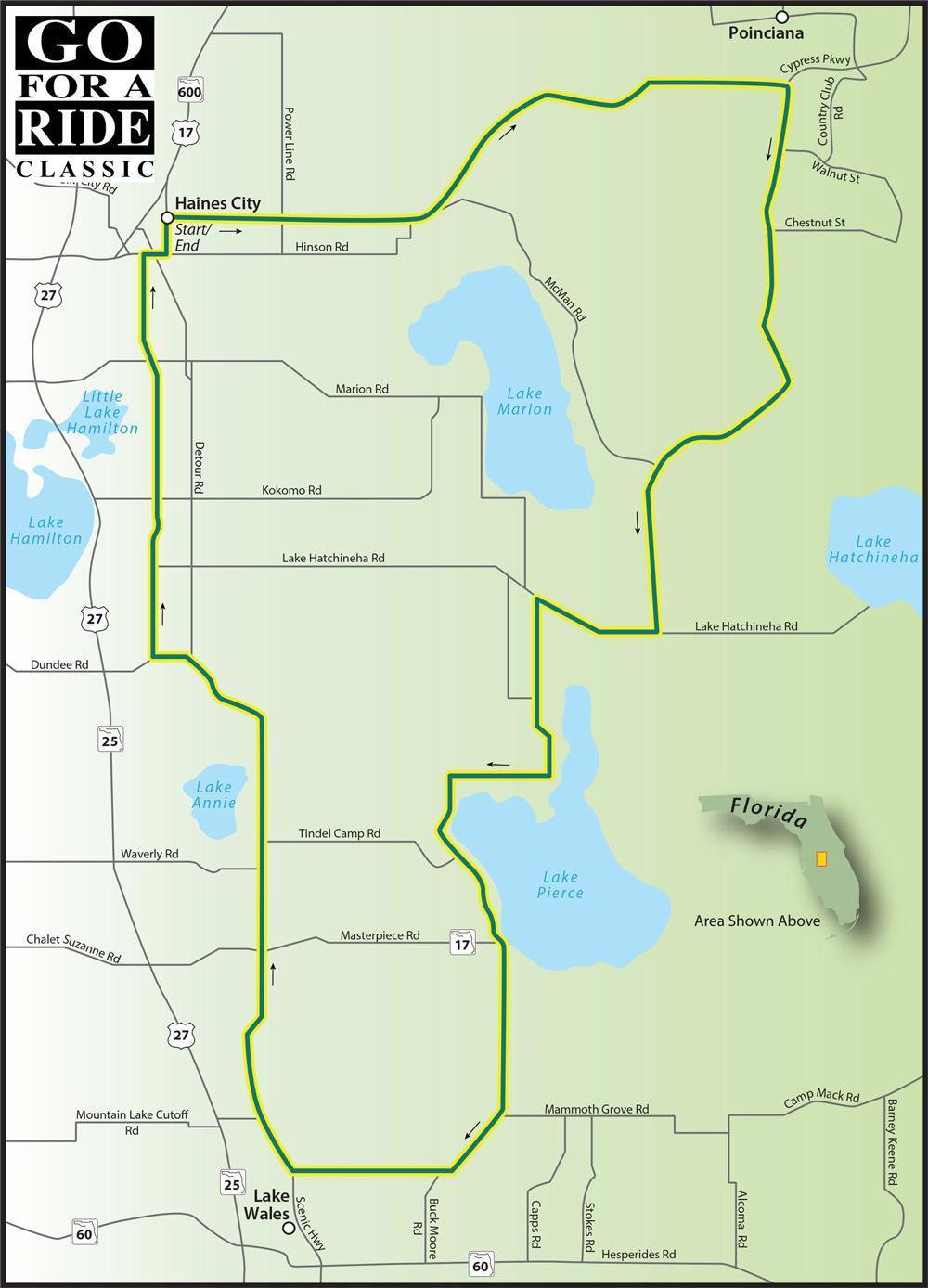
Haines City’s history incluldes agriculture and this ride gives you a chance to see some of that old fashioned rural charm meeting up with modern society’s urban growth.

Road Name – Direction – Miles

  1. Start in Haines City at US 92 and E Johnson Ave
  2. E Johnson Ave/CR 580 – East – 1.5 Miles
  3. Marion Creek Rd/CR 580 – Straight – 8.4 Miles
  4. Becomes Cypress Pkwy
  5. Marigold Ave – Right – 4.5 Miles
  6. Poinciana Pkwy – Right – 4.9 Miles
  7. Lake Hatchineha Rd – Right – 1.9 Miles
  8. Watkins Rd – Left 2.1 Miles
  9. Canal Rd – Right – 2.0 Miles
  10. Timberlane Rd – Left – 2.9 Miles
  11. Masterpiece Rd/SR 17 Alt – Left – 5.8 Miles
  12. Burns Ave – Straight – 0.1 Miles
  13. SR 17 N – Right – 8.8 Miles
  14. Center St/SR 17 N – Right – 5.9 Miles
  15. E Hinson Ave – Right – 0.3 Miles
  16. US 17 N – Left – 0.5 Miles
  17. Returns you to the starting point.

Download PDF

Continue reading